Above the Well

AlanLichty

Moderator
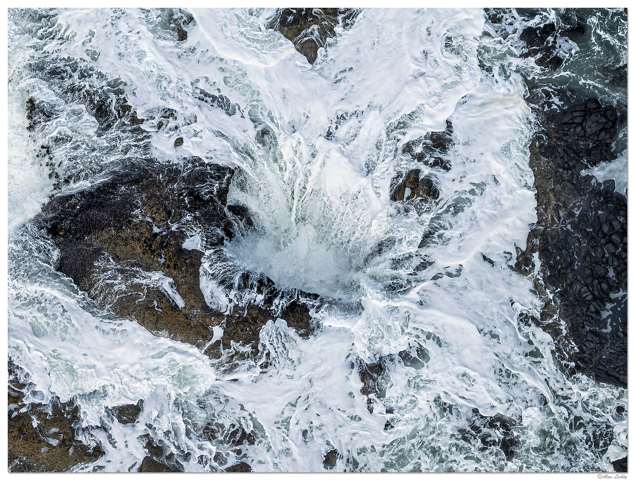
A drone's eye view of Thor's Well at Cape Perpetua viewed through a telephoto lens. A rare high swell day with relatively low winds allowed me to get some nice aerial views of the waves rolling over this basalt formation with the high water keeping people on the ground at a distance.

DJI_M3_161_TWell103022.jpg


C&C always welcome.
 

JimFox

Moderator
Staff member
That's so cool and unique. It almost comes across as an abstract, I know I was trying to figure out what I was seeing until I read your description.

Awesome!
 

AlanLichty

Moderator
That's so cool and unique. It almost comes across as an abstract, I know I was trying to figure out what I was seeing until I read your description.

Awesome!
Thanks Jim - its kind of fun to approach iconic scenes like Thor's Well from the ocean point of view looking back at the land since that's not how we are used to seeing them :)
 

Jameel Hyder

Moderator
Staff member
Nice view point for this. I haven’t been there since I got the drone. Have to plan a trip. I do wonder if there is sufficient wave action, how well can a drone handle it.
 

AlanLichty

Moderator
Nice view point for this. I haven’t been there since I got the drone. Have to plan a trip. I do wonder if there is sufficient wave action, how well can a drone handle it.
Thanks Jameel - it's a bit of a crap shoot for the swells and the wind. I have been there several times with my MP3 where the drone stayed in its bag because the wind was way too strong but every once in a while you get good swells and low winds. I have dropped by this place almost a dozen times since I started flying and got good flying conditions about 50% of the time.
 

TimMc

Well-Known Member
@Jameel Hyder , @AlanLichty

How much wind is too much runs in my head way too often. Normally flags out straight tells me no. Wind gusts over 20 mph has been a no. But with a reasonably safe area to fly in I have occasionally pushed those limits and typically find my drone just ignores the wind. How do you guys identify the wind limit for your flying?

Should have started with "Fantastic shot Alan, congratulations "
 

AlanLichty

Moderator
@Jameel Hyder , @AlanLichty

How much wind is too much runs in my head way too often. Normally flags out straight tells me no. Wind gusts over 20 mph has been a no. But with a reasonably safe area to fly in I have occasionally pushed those limits and typically find my drone just ignores the wind. How do you guys identify the wind limit for your flying?

Should have started with "Fantastic shot Alan, congratulations "
Thanks Tim - I don't carry an anemometer with me when I go out to fly (@Beth does) so its strictly seat of my pants but winds that would have a flag straight out would give me pause. I have flown in winds around 25-30mph with some higher gusts that gave me wind warnings on the controller screen strongly advising me to get my drone out of the sky. I do watch the attitude box down in the corner of the controller screen and when I can see that the drone is hovering at angles in the 15-20º range its likely going to impact your images and you are very close to getting warnings. Top speed on my Mavic 3 Pro is 42mph in Sport mode so flying into that as a headwind won't work too well. Beth has to fly in conditions like that for her job but she isn't risking her personal drone in those conditions.

Out along the coast like the area above has another issue - the winds are almost invariable blowing onshore and there are cliffs right behind the highway that could leave your drone looking like a bug that hit your windshield on the freeway. Winds that could do that are not uncommon at all during the winter months when I usually visit the place. I also run into gusty winds like this up in the Columbia River Gorge more often than I would like. That's where I got used to what kinds of gusts would be more problematic than I would like. I did one flight near Wahkeena Falls where I got the in-flight warnings and when I got the drone down to about 10' above the ground the winds were pushing the drone 5-10' sideways with every gust so no hand catches for that landing. I almost had the props skimming the pavement as it landed.
 

Beth

Well-Known Member
@Jameel Hyder , @AlanLichty

How much wind is too much runs in my head way too often. Normally flags out straight tells me no. Wind gusts over 20 mph has been a no. But with a reasonably safe area to fly in I have occasionally pushed those limits and typically find my drone just ignores the wind. How do you guys identify the wind limit for your flying?

Should have started with "Fantastic shot Alan, congratulations "
as alan said, i've used an anemometer to measure wind speed on the ground. but usually we just use a weather service like noaa or windy to look at the sustained wind speeds and the gusts. i've flown in gusts around 50 mph after a tornado, that's not fun. in those cases you pretty much just stop the drone when the gusts get too bad and let it hover (or drift whatever way it gets blown) and get it back on track after the gust dies down. or, if possible, you can land and hope you can get it back in the air again. when i was flying after a tornado, so landing wasn't a great option due to all of the debris and power lines down. the bigger and/or newer drones can take more wind than the smaller or older ones.
 
Last edited:

AlanLichty

Moderator
@Jameel Hyder , @AlanLichty

How much wind is too much runs in my head way too often. Normally flags out straight tells me no. Wind gusts over 20 mph has been a no. But with a reasonably safe area to fly in I have occasionally pushed those limits and typically find my drone just ignores the wind. How do you guys identify the wind limit for your flying?

Should have started with "Fantastic shot Alan, congratulations "
There are resources you can use to get an idea of what is going on near you. One of the best I have seen is a site set up for wind surfers. They have been quite resourceful in finding home weather stations with online data they can harvest for wind conditions. I have a home station and they asked me if they could use my site as a data point and I grabbed their web site info so I could use it for places I want to go fly. Always worth noting that the air speed on the ground isn't necessarily the same as what you will experience when you are a couple hundred feet above the ground - its usually quite a bit higher once you get above obstacles on the ground that slow the wind down.

Our drone gimbals do an amazing job of making it look like things are calm in the air which is why I keep the attitude indicator up in the lower corner of the controller screen. It can look like everything is fine on the viewing screen and then you notice that your drone is at a 20-30 degree tilt into the wind fighting to stay in place.
 
Top Bottom