Woahink Lake

AlanLichty

Moderator
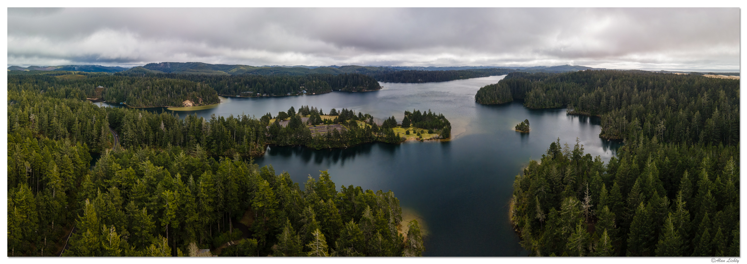
Large lakes aren't usually what springs to mind for the area near Florence Oregon since things are typically oriented to the extensive sand dunes in the area. Stabilized dune fields often form natural dams that have created several fairly large lakes inland from US101. Three of the lakes are just south of Florence and are large enough that the 400' ceiling for flying my drone is not high enough to show any of these lakes in full. This is a 4 shot panorama of the first lake named Woahink Lake. The other two larger lakes are Siltcoos and Tahkenitch Lakes.

Almost all of the land in this scene consists of stabilized sand dunes. Click through for a larger version.


WoahinkLake.jpg


C&C always welcome.
 

AlanLichty

Moderator
Fun to see this lake which I am aware of but had never seen in perspective.
Thanks Ben - I have driven past signs for them along US101 dozens of times but have only really seen them from maps and glimpses of them from the road. I tried wandering around the backside of these lakes but most of the area is unsuitable for my RV. I did wander down one road a bit too far and had the "pleasure" of driving about 1/4 mile of a twisty one lane road uphill in reverse to find a spot where I could turn around. This is an area I want to explore with my truck.
 

AlanLichty

Moderator
Nice looking lake and some ominous clouds. The pano looks nice esp. in the larger version.
Thanks Jameel - I didn't know it at the time but there is a parking area out on that spit of land in the center of the scene where a better view should be available. I do have some shots of Tahkenitch but couldn't access the better viewpoints with my RV so I chalked it up to scouting for another trip up the road without it.

Those clouds weren't as ominous as what hit Florence yesterday. We had a high wind warning with an inch of sideways rain since yesterday afternoon.
 

JimFox

Moderator
Staff member
Woah! A lake named Woahink? :)

First off, I hadn't heard of this lake before, and the name is a bit on the crazy sounding side. It must be an Indian name given the names of the other 2 lakes?

And this is a really cool pano. With all of the trees surrounding this lake, there is just way without a drone or a plane that one is going to get any inkling of how cool this lake looks.
 

AlanLichty

Moderator
Woah! A lake named Woahink? :)

First off, I hadn't heard of this lake before, and the name is a bit on the crazy sounding side. It must be an Indian name given the names of the other 2 lakes?

And this is a really cool pano. With all of the trees surrounding this lake, there is just way without a drone or a plane that one is going to get any inkling of how cool this lake looks.
Thanks Jim - yes the names come from the Native Americans who first inhabited this region. I was just under 400' and found myself thinking that you would need at least 1000' to see all of the arms of this lake and this is smaller than Siltcoos and Tahkenitch. This is an area I want to explore further with my truck instead of my RV. The drainage basin that feeds these three lakes is the other side of the ridge from Sweet Creek on one side and the Smith River on the other. I have driven past these lakes on US101 dozens of times and have only seen their shapes on maps and Google Earth. The views from US101 don't really even hint at their size.
 
Top Bottom