Waterfall Wednesday 9/14/2022

AlanLichty

Moderator
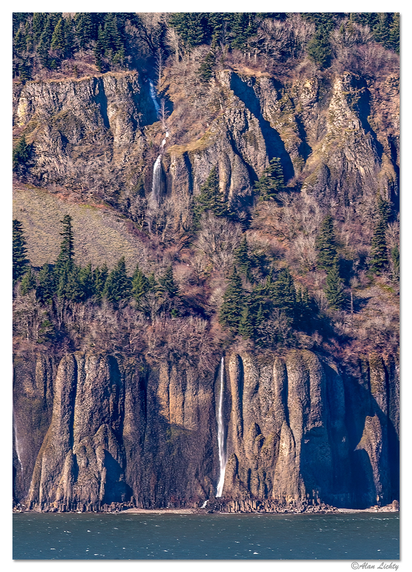
There are some falls in the Columbia River Gorge that really can't be seen up close. Cape Horn Falls on the Washington side of the river are an example. The best viewpoints I have found are either from the air with my drone or from the Oregon side of the river with a telephoto lens. I don't have a launch point that will let me get a full view of the falls with my drone and still have a visual line of sight to the drone so have only been able to get the lower tier of the falls in the frame. This image was taken from a small trail near Bridal Veil Falls on the Oregon side of the river using a telephoto lens.
CRG-CapeHornFalls020603.jpg


Pile on with your own waterfalls.
 

AlanLichty

Moderator
Alan thanks again for starting this next 5 years of Weekly Waterfalls. Neat image, it looks more like two falls, as the distance between them us pretty large. My big problem with telephoto waterfalls is atmospheric haze which you have handled very nicely


Multnomah falls in the normal composition.
Thanks Ben - there was a bit of haze to contend with. Hard to go wrong with this classic view of Multnomah Falls.
 

Ken Rennie

Well-Known Member
Cascade du Rouget. The Sixt Fer a Cheval area of the French Alps. The valley floor is surrounded by a 3 mile wide horseshoe (Fer a Cheval) of cliffs that look to be several thousand feet high to my untutored eye. Many waterfalls stream down from the cliffs, this is the highest a double drop of 260ft. Above this fall are several others but I didn't have the time, or energy, to explore the higher reaches. Ken

I have posted an image like this before but this is a completely new version
_DSF9867v4.jpg


Previously unprocessed 4 shot panorama
9806 to 9809 panorama copy.jpg
 

JimFox

Moderator
Staff member
Cascade du Rouget. The Sixt Fer a Cheval area of the French Alps. The valley floor is surrounded by a 3 mile wide horseshoe (Fer a Cheval) of cliffs that look to be several thousand feet high to my untutored eye. Many waterfalls stream down from the cliffs, this is the highest a double drop of 260ft. Above this fall are several others but I didn't have the time, or energy, to explore the higher reaches. Ken

I have posted an image like this before but this is a completely new version
View attachment 52310

Previously unprocessed 4 shot panorama
View attachment 52311
What a neat waterfall, I like that first one a lot as it's a great angle, but the pano of #2 is really inviting too.
 

AlanLichty

Moderator
Cascade du Rouget. The Sixt Fer a Cheval area of the French Alps. The valley floor is surrounded by a 3 mile wide horseshoe (Fer a Cheval) of cliffs that look to be several thousand feet high to my untutored eye. Many waterfalls stream down from the cliffs, this is the highest a double drop of 260ft. Above this fall are several others but I didn't have the time, or energy, to explore the higher reaches. Ken

I have posted an image like this before but this is a completely new version

Previously unprocessed 4 shot panorama
I love the big wide view in the panorama but the first one wins me over with the light and the shutter speed.
 

AlanLichty

Moderator
Another wide top down view of the Chocolate Falls taken with the DJI Mini 2 drone. You can see me and the new 4Runner in this.
Gotta love the aerial view - this would be amazing with a full flow. From this altitude you get a better perspective on just how low the water level really is compared to the path the river has carved out.
 

AlanLichty

Moderator
I am glad I am able to celebrate another Waterfall Wednesday with you, Alan. This is another from my archives. Here is my contribution of Wilson Falls in Sedona after a Monsoon storm.
Neat little set of falls to celebrate with too - nice to see red rocks of Sedona along with the falls too.
 

JimFox

Moderator
Staff member
Gotta love the aerial view - this would be amazing with a full flow. From this altitude you get a better perspective on just how low the water level really is compared to the path the river has carved out.
Someone alerted me that it's flowing pretty good right now. When I shot it, that was about 10 cubic feet per second flow. Right now it's at between 1000 and 2000 Cubic feet per second. Max monsoon looks to be about 6000. So it wouldn't be max flow, but 100x the flow I had should be a wall to wall flow I would think.

So I am being encouraged by a few people to run back over there. It's about 18 hours there and back.... I am debating if I want to go, if you hear some tires spinning on gravel, you will know that I am on the road... ;)
 

ProCaliberTraveler

Well-Known Member
This isn't my video, but it was taken by an employee of Death Valley National Park this past Saturday. It shows the waterfalls that developed along Badwater Road near Natural Bridge as the result of all the rain. This rain damaged the state highway through the park, which closed approximately 100 miles of it. There are many areas where the state highway has been washed away. Stunning scenes.

As for this clip, I wish I was there to see it myself!
 

AlanLichty

Moderator
This isn't my video, but it was taken by an employee of Death Valley National Park this past Saturday. It shows the waterfalls that developed along Badwater Road near Natural Bridge as the result of all the rain. This rain damaged the state highway through the park, which closed approximately 100 miles of it. There are many areas where the state highway has been washed away. Stunning scenes.

As for this clip, I wish I was there to see it myself!
Whoa - that is amazing - wish we could see a whole lot more of what that must have looked like around the park. Thanks for sharing this.
 
Top Bottom